
Metro Cebu is obviously a very well developed city. Highly urbanized, it offers locals and foreigners alike countless opportunities for work, living, and leisure. But just like in any highly urbanized metropolis in the world, something must inevitably give way. In most cases, it is nature that is forced to step aside. Cebu’s rapid growth and progress has led to denuded forests, cleaved mountainsides, damaged reefs, polluted waters, and dried-up rivers.
Reading from the paragraph above, you may have a perception that Cebu is an environmentally doomed city. You may have an image of Cebu that is a filthy, polluted, and devoid of forests. Well, hardly. Cebu still has a rich plethora of wild places carefully tucked into its highlands. If you know where to look, you will find breathtaking natural treasures that are worth a hearty adventure. And they’re just right in the city’s own backyard!
We had the opportunity to discover one of these treasured wildernesses last May 5, 2013, Sunday, through the help of Sir Sien, a close mountaineer friend of ours. After our Palawan anniversary tour, Sweetie and I decided to have a practice climb in preparation for an upcoming major climb this coming July 2013. Sir Sien immediately suggested a trek from Quiot, Pardo, Cebu; climb up and traverse the southern ridge of Antuanga (pronounced An-to-wa-nga) Ridge; then exit at the DENR reforestation area in Buhisan. Upon exiting, he recommended continuing the trek to Jaclupan in Talisay and finishing up in Igotan Cave. We figured it would take us 6 to 7 hours of trekking and climbing to complete the route, a fairly good-sized hike. A few friends, particularly Angel and Morey and their pals, wanted to tag along with us.
We met up at the McDonald’s outlet in Mambaling on one extremely sunny Sunday. Sir Sien fetched us then we proceeded to our jump-off point at San Carlos Heights where a few other hikers were waiting for our group. After a short prayer, we were on our way to Antuanga Ridge.

The first few kilometers involved a steady climb on a concrete road. Basically, we are climbing towards the exit of San Carlos Heights. As we neared ridge’s southern ridge and the radio towers that dot it, the road became rough and rugged.

We figured that the road we’re walking on is part of a local pilgrimage trail due to the presence of Way of the Cross stations. During Holy Week, this place must be chock-full of people.

As we climbed higher, an encompassing and splendid view of the Cebu metropolis opened before us. The forest of towering skyscrapers, dozens of T-cranes, gigantic malls and buildings under construction, and sprawling communities signify the Cebuanos’ desire for Cebu to be a world-class city. And at this point, we can literally see the city’s progress.

Sweetie and the City! Hehehe! We simply love our city’s skyline. We reckon that in just a handful of years from now, Cebu City will have a skyline that will rival those of Surabaya in Indonesia, Melbourne in Australia, Cordoba in Argentina, and other second-tier cities. Yes, we are proud Cebuanos.

Angel, Morey, Apol, and Sweetie found a nice nook to seek refuge from the sun’s power. It was just past 8 AM, and the sun was already scorching.

A short while later, we went off-trail to climb a steep hill to get to the start of the southern tip of the Antuanga Ridge. Loose rocks riddle the entire hillside so be careful when ascending here.

We stopped to drink in the grandeur of Cebu’s coast midway up the hill. Check out the road below us so you can gauge how high the hill is.

The hot, bright morning sun was practically baking the landscape. Thus, we were quite thankful when we saw this thick-canopied tree that stood beside the trail. You know, when you are into outdoor adventures, you tend to appreciate trivial things that you normally would take for granted like the shade that a tree offers. We stopped here for a few minutes to rest and to cool off.

A short rest and we were ready to go again. The road (yes, it’s not a trail at this point) led us higher along the ridge until we came right under the massive towers that supply electricity to the city. If our hunch is right, these towers support electric cables that originate all the way from the power plant in Naga or Toledo. Needless to say, roads are established to allow technicians easier access to these towers.

The “true” hiking/climbing trail of Antuanga Ridge started right after we passed the last electrical tower. But before we proceeded to the mountain’s spine, we found a store in Sitio Antuanga that offered ice-cold Coke and Sparkle, which are truly a mountaineer’s delight on a hot day. Cold soda is unhealthy, but up there under the heat of the sun, these cold drinks are sheer bliss!
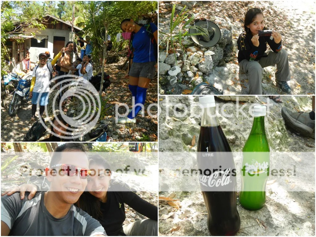
After taking huge swigs of Coke and Sparkle (and keeping some in our water bottles) to quench our thirst, we started a grueling ascent up the ridge. As you can probably tell in the photo below, the day was cloudless, and the trail was overly exposed. Imagine how hot this day must be. Too bad we didn’t bring along a thermometer.

Along the way, we met a family of local woodcutters. They cut the branches of dead, dry trees somewhere then sell these branches as fuel for wood-fired stoves or burn them for charcoal. These folks gain profit at a razor-thin margin considering the great effort that they exert in harvesting these woods (for starters, just imagine cutting and carrying wood for hours under the sun). And with the advent of electric and gas-fired ovens and ranges, the business of serving the needs of those who still use wood or coal-fired stoves is rapidly declining.
Personally, this is a good thing. Foremost, trees are spared, and the mountain will have a chance to rehabilitate itself. Second, they will have to use more efficient and eco-friendly equipment for cooking. Businesswise, this might be grim for the woodcutters, but they have to adapt to a changing world.

It was already 10 AM, and we’re racing to take refuge under the shade of that hut. That hut marks the topmost point of Antuanga Ridge. Sir Sien and bushman extraordinaire Sir Jing of Camp Red said that this ridge and Sitio Antuanga, which this ridge is named for, is full of tunnels that were dug by Japanese troops during World War 2.

On this ridge, you can see the full glory of the Cebu province. The breathtaking panorama that encompasses azure summer skies, verdant fields, turquoise waters, the distant blue mountains of Bohol, and the cityscape below made us feel humbled and honored. It’s not every day that we witness incredible vistas such as this. Indeed, at this vantage, it’s not difficult to understand why Cebu is considered as one of the best islands in the world.

The hut seems to be a rest area for woodcutters. And it offers a very beautiful view of Cebu City, the South Road Properties, the Mactan and Hilutungan Channels, and faraway Bohol, all in the foreground of a blue summery sky.

Tiny tomatoes! They’re actually cherry tomatoes, and they’re perfect for hors d’oeuvres.

A vastly different view of Cebu greeted us when we surveyed the northwest part of Antuanga Ridge. Cliffs, hills, light woods, and more mountains fill our vision. Focus on the bottom right photo. Can you see the woodcutters?

After half an hour of resting, we continued our trek. As you can see, the summer sun was so hot that it burned leaves and bushes. But as we descended and entered the upper ridge of the DENR protected forest in Buhisan on the other side of the mountain, the flora once again became verdant and alive. The farther we went, the greener the plants seemed.

We followed a treacherous trail, the danger compounded by loose soil, above the reforestation area. At some portions, the trail is just wide enough to accommodate half your foot! One misstep to the right and you’ll be careening down the steep, slanted slope.

The changing scenery has much to be admired. So Sweetie and I decided to practice on our nature photography skills (specifically, composing the photo with unique angles) while trekking. I say we did a pretty good job, don’t you think? Entering the Buhisan reforestation was like entering a different world if only for an hour or less.

As we continued downhill, we heard a familiar sound—the unmistakable buzzing of a motorcycle’s engine. Could it be?

Indeed it was! We found a road!
Going to the right leads you to Buhisan Dam where the Metro Cebu Water District gets the bulk of its water. Going to the left, the direction of our hike, leads to a secluded barangay called Toong.

Arriving on the road, the team was so happy that Apol and Angel did a few cartwheels. Hehe! When you’re out there in the wilderness, the sight of a road in the middle of nowhere is always a welcome. With trees forming a wall on either side of the road, the road makes a cool postcard-perfect photo.

A few minutes of trekking led us to Barangay Toong where we refreshed ourselves with some Coke and biscuits. Feeling energized, we continued our trek towards a hidden river that divides barangays Toong and Jaclupan.

Along the way, the team met a couple of vendors selling fresh jackfruit, pineapples, and coconuts. We bought some for our dessert later on. The nice thing about buying fruits here is that you can save a lot; they cost less than when sold in the city. And somehow, they’re tastier here in the mountains.

We veered off the cemented road and followed a dirt trail that led us to a riverbank. As you can see, there are greens everywhere even though the area is quite populated.

After a quarter of an hour, we reached the riverbank. On a hot, sweaty day like this, the mere sight of a river is bliss. You’d know that somewhere out there is a cool pool or rush of water that is totally refreshing. Sweetie and I were even tempted to take off our shoes and just immerse our feet in the water.
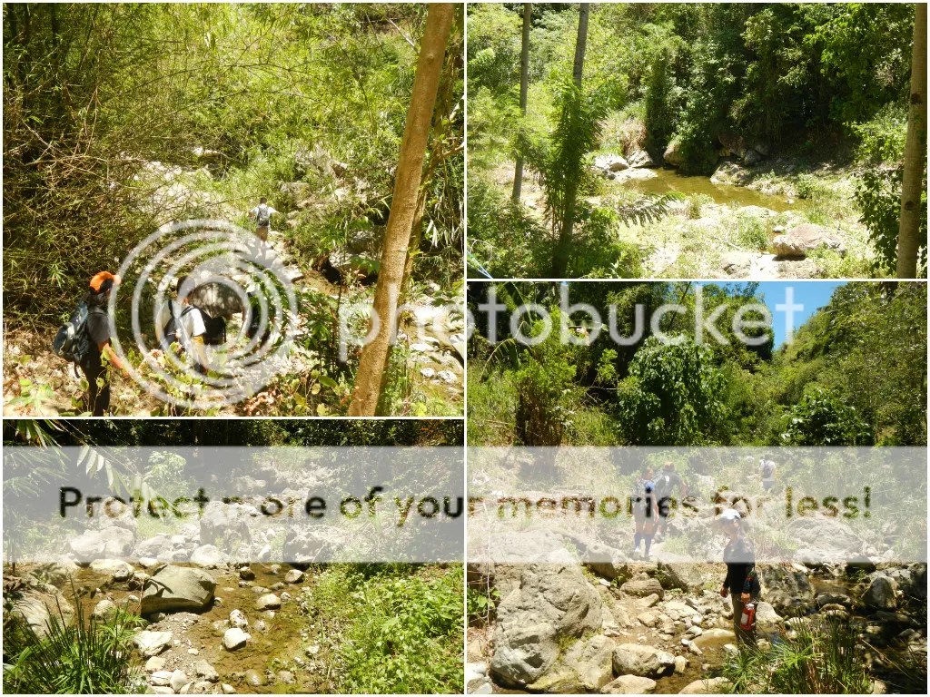
The river-trekking segment of our adventure started. Watch your step and be careful here. Those rocks can be slippery due to the moss that clings on them.

Following the river led us to small patches of civilization. We even found a sari-sari store in what it seems to be the middle of the jungle! Farms, catch basins, small plantations of orchids, and a creaky bamboo bridge all add to the provincial feel of the place even though technically, we’re still in Metro Cebu!

It was also my first time to see a mango tree in full bloom. It looked amazing with green leaves and yellow baby mangoes blending together seamlessly. The air was redolent with the sweet scent of fresh mangoes. The scent itself reinvigorated us, giving us new energy to continue with our river trek.

As we trekked for half an hour upstream, we heard the laughter and screams of children and the unmistakable rush of water. Hearts racing, we realized that our hot morning ordeal was almost over!

We reached a nice, basin-like pool that, we think, is quite deep. Locals call this “Linaw” (Visayan word for “clear”) although the water proves otherwise. Actually, the greenish tinge is from the algae at the bottom and sides of the basin. The water here is really clean although it is not potable.

Moving farther up, we arrived at the second tier and the highlight of the river, crater-like sinkhole. Locals call this “Kawa” (Visayan word for frying pan or wok) after the wok-shaped sinkhole. For us, it looked very much like the impact site of a meteorite or comet. Could our hunch be true? Well, we would never know unless geologists excavate the area for traces of iridium, which, of course will destroy this unique river formation.
When we got to Kawa, a number of young kids and teenagers were already there, having fun and cooling off in its cool waters.

Our lunch area is a flat piece of rock above the Kawa, so it involved a little bit of an uphill climb. From there, we can see a very clear view of Kawa’s crater. It really looks deep, but it should be a fun diving spot.

In just a few minutes, we found the perfect nook where we could have lunch, a relatively flat piece of rock beside the river and sheltered by shady trees. You can pull off your shoes and socks then dip your feet inside these pools.

Lunch time! We had all sorts of lunches, from Styrofoam-packed value meals from McDonald’s to a boodle-style mishmash of rice, chicken, and viand. Bon appétit!

After we had our fill, we rested for a little while before Sir Sien announced that it was 1 PM, meaning, it was time to go. We packed up our mess, re-packed our bags, and climbed a steep hill that serves as the gateway to Barangay Jaclupan. At certain parts of the hill, the trail becomes dangerously narrow and slippery; a misstep to the left can send one careening down a steep slope. It was tricky, especially when we encountered a group of youngsters who were on their way to the Kawa.
But after a short while, the trail eased up and entered a lightly wooded area. From there, it is a continuous 1-hour descent.

Along the way, we saw interesting subjects and viewpoints. Again, it was time to practice our nature photography skills. Take note, these photos, as well as all photos in this blog, were NOT Photoshopped. We did a pretty good job, wouldn’t you agree? By the way, those lei-like flowers belong to a family of gumamelas.

After almost an hour of walking through light woods, we found signs of civilization such as galvanized roofs, the whine of a motorcycle’s engine, and an off-key voice trying to catch up with a song’s tempo played by a karaoke machine. We were finally in Barangay Jaclupan, which, we suddenly realized, is a barangay that we always pass by when we take a V-hire to Cantabaco.
We rewarded ourselves with a few bottles of Coke and Red Horse beer, a few snacks, and the biggest ice candies we’ve ever seen!

After a short rest and finishing up two bottles of Red Horse, we proceeded to our last stop, which is the Igotan Cave.
Suggested Itinerary
7:00 AM – meet-up at McDonald’s, Mambaling
7:15 AM – ETD McDonald’s Mamabaling, going to San Carlos Heights, Quiot Pardo (Ride a 09F jeepney bound for Quiot, Pardo and tell the driver to drop you off at at the San Carlos Heights entrance)
7:30 AM – start of trek and ascent to ridge
9:00 AM – ETA ridge summit, rest in hut
9:30 AM – ETD ridge summit, going to Buhisan DENR reforestation area
10:30 AM – ETA Barangay Toong, refresh and refill
11:00 AM – ETD Baragay Toong, trek to Linaw and Kawa
12:00 PM – ETA Linaw and KAWA, lunch
1:00 PM – ETD Linaw and Kawa, going to Jaclupan
2:00 PM – ETA Jaclupan, rest
2:30 PM – ETD Jaclupan, hike to Igotan Cave
3:00 PM – ETA Igotan Cave, explore cave and bathe in the cave’s waterfall
4:30 PM – ETD Igotan Cave, ride a Jaclupan jeep bound for Tabunok, Talisay
5:00 PM – ETA Tabunok, Talisay, separate ways to Cebu
Estimated Budget per Person
P 8 – jeepney fare from McDonald’s Mamabaling to San Carlos Heights
P 10 – jeepney fare from Jaclupan to Tabunok, Talisay
P 5 – gate entrance fee (in case you don’t want to go inside the cave)
P 20 – cave entrance fee
Total Estimated Budget per Person: P50 (excluding lunch, snacks, extras, and fare to and from home)
Tips
1. For guideship services, contact Sien Kha Hey at 0922-6351960 or 0916-9676753. You can also find him in Facebook, or visit his page Freedom Canyoneering. Please negotiate the guide fee with him.
2. The traverse from Quiot, Pardo to Jaclupan is perfect for cash-strapped adventurers. As you can probably infer from the estimated budget above, this trek is pretty cheap. You’ll probably spend more on drinks and snacks than the actual essentials of the trip itself.
3. The trek to the southern ridge is extremely exposed with virtually no shelter. Thus, don’t forget to bring a wide-brimmed hat, scarf, or umbrella to protect yourself from the heat. Don’t hesitate to tell the guide to stop if you feel exhausted.
4. Wear arm guards and trekking pants to protect your skin from the sun and prickly plants. Also, a dry-fit shirt or rash guard will help keep you cool.
5. On your way and inside the DENR reforestation area, be in visual range of each other. At the early part of the trek after you leave the summit hut, the trail splits into four. If the gap is considerable, the tail end of your group won’t be able to see the lead group due to the thick vegetation blocking your line of sight. Always be on the lookout for the person behind to ensure safety.
6. Be careful when negotiating the trail in the DENR reforestation area and the exit trail in Jaclupan. These trails are cut into a mountain slope, and in some points, they are so narrow that a misstep to either side will send you careening down steep slopes. Also, loose soil might cause you to slip, so don’t hesitate to grab hold of strong roots or shrubs for balance.
7. Wear trekking shoes or sandals with an aggressive tread. You will need a lot of traction since you will be scrambling over loose soil and slippery boulders.
8. Bring salt tablets or ion-filled beverages such as Gatorade, coconut water, or fruit juice aside from water. The hot sun, multiple ascents, and exposed trails can make you sweat a lot. When you lose enough ions and salts via your sweat, cramps will occur. If cramps happen, rest for a while, drink a lot of water or ionic drinks. This will replenish the ions in your system.
9. Bring energy-rich trail food such as nuts, crackers, bread, and bananas. Don’t underestimate the mountain.
10. Pack light but do bring the following:
- water (at least 2 liters)
- trekking attire
- trekking shoes or sandals with aggressive tread (terrain is rocky)
- umbrella, hat, or scarf (terrain is exposed and hot)
- packed lunch
- trail snack
- helmet (protection for caving)
- headlamp (for caving)
- rain gear (in case of bad weather)
- extra money for emergencies
11. Don’t forget to waterproof your belongings. You can do this easily by wrapping your stuff with plastic bags or zip-lock sandwich bags before putting them inside your pack.

Great images, very well-documented and precise. Makes your adrenaline rise even when you are on an armchair.
Hi Sir Jing (a.k.a. the Trailhawk)
Thank you, sir! There was one point in Antuanga ridge where we could see your playground Mt. Babag. 🙂
Sparkle! Savior after a long hike under the blazing sun! 😀
Hi Mustachio,
Indeed! Having that cold Sparkle trickle down your throat during a hot day is simply bliss!
This should be my next trail. Salamat sa guide! Sweet!
Hello Vergielyn,
Thanks for taking time to visit our blog. Yes, the Quiot to Jaclupan trail is nice, offering great views of the surrounding areas. However, the trail is extremely exposed, so we highly recommend bringing all the sun/rain protection you can muster. 🙂
thanks guys. Will do!
Two thumbs up for the well documented blog. I remember this mountain when I was still starting to appreciate hiking. Allow me to share a video we made in this climb.
Hello Jason,
Thank you for the compliment. This hike was actually one of the most enjoyable hikes we had.
Your video is awesome!
cool! Suwayan niya ta ni 😀
Sure! It’s a very nice trek. 🙂
Seriously, this is one of the best local blogs ever!!!! Now I know where to start my MTB ride up to this magnificient place and view. Thanks a lot and more power to you.
Hi Ferdinand,
Thank you very much for the compliment. 🙂 Keep traveling and adventuring!
[…] Jaclupan Trail […]