
It is always a good feeling when you are that kid in the block who discovered something new or did the first of something. For us, mountaineers, discovering a new trail or mountain is our Holy Grail. And in 2011, we had our Grail. Together with my outdoor buddy Sir Ruel and a small team of mountaineering friends, we made an exploratory expedition and found a way to the summit of a relatively unknown but beautiful mountain in Ginatilan, Mt. Hambubuyog.
Locals visit the Divine Mercy Chapel, which rests on its summit; and farmers plow the hills surrounding the mountain. However, ours was somewhat a semi-official first ascent as we were the first to trek our way from Inambakan Falls near the Ginatilan town center. Virtually most locals, on the other hand, ride a habal-habal to the Chapel in the neighboring municipalities of Oslob or Samboan. In fact, the barangay captain of the community where the summit is located said that we were the first people to climb the mountain from the Ginatilan side!
Three years since our first ascent, Sir Ruel and I decided that it was time to revisit Bee Mountain, our nickname for Mt. Hambubuyog. A group of mountaineering friends and a few members of Body and Soul Outdoors (BASO) who were eager for adventure joined us.
After a refreshing mid-morning dip in Inambakan Falls, it was time to work towards the main objective of this early-year adventure, the sacred summit of Mt. Hambubuyog. The cold dip was a boon to everyone as we were about to endure several hours under a scorching sun.

Along the way, we met these nice folks weaving and making fresh nipa sheets which will be used to assemble the steep, sloping roofs of traditional bahay kubos. The sheets will be assembled in layers to help waterproof the kubo.
Obviously, this is hard work, but we learned that these guys will only get around P20 for each sheet sold in the market. Obviously, the margin for profit is razor thin.

At the top of Inambakan Falls was a steep trail that was a real pain to ascend. No, not because we had to fight gravity but because of the thorny, sword-sharp plants that kept caressing our limbs. It was a good thing most of us were wearing tough trekking pants to protect us from most of the itchy thorns.

Let us say that you’re lost in the woods then suddenly, you hear the sound of an axe hitting the trunk of a tree. There should be a woodcutter nearby, right? Human civilization, at last!
Well, don’t let your hopes up yet. It might just be the sound of bamboo stalks hitting each other as they sway in the wind.

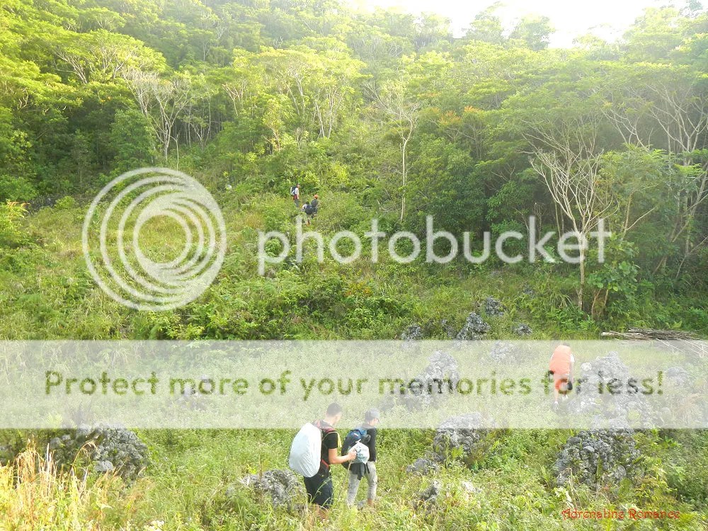
We made it out of a somewhat dense jungle and into an open hill. The well-established trail signifies that this is a harvester’s trail which residents use to go to their farms.

The steep ascent and the hot sun drained us, so we took our first rest of the adventure to recuperate and re-energize. It was also an opportunity for us to lighten our loads as we took out our snacks.

After 10 minutes, we were back on our feet and continued to trek until we came to a wide anopog road. Following the road led us to a small community where we decided to have our lunch break. Kind homeowners allowed us to take lunch on their property, use their bathrooms to relieve ourselves, and refill our water bottles from their water containers. And the best thing? There was a nearby store that sells ice-cold soft drinks!
This is yet another proof that people in far-flung communities are some of the friendliest and most accommodating folks in the country. They are true bearers of our world-renowned trait: genuine hospitality.

Finishing a filling, softdrink-laden lunch, we thanked the homeowners and continued down the road. This is actually used by habal-habal drivers who transport goods, produce, livestock, and people to and from the Ginatilan’s hinterlands.

After rounding a few corners and just like a theater curtain, the majesty of Mt. Hambubuyog showed itself before us. Just look at that massive, forest-covered slope! And that’s just the back of the mountain.
The main trail took us at the side of Mt. Hambubuyog before it connects with another trail that marks the actual assault.

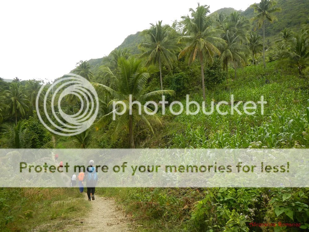
The farther we hiked, the narrower the road became until it became a foot trail once again. On the way, we passed small patches of green corn farms and coconut groves.
One of the best things about hiking and mountaineering in the Philippines is that you get to realize that there’s more to life than careers, video games, computers, gadgets, cars, bars, etc. Snippets of rural life such as woodcutters having a break, pigs taking refuge from the sun, or woodcutters working bring us back to the realization that happiness, tranquility, peace, and life can be had in simple ways.

The side of Mt. Hambubuyog is dotted by tall but hidden limestone rock faces. It would be quite difficult to access them due to the thick vegetation that surrounds them.

We passed by a large tract of farmland. Farming still remains the far-flung community’s main industry as it was many decades ago.

We had been trekking for around three hours. After a short rest along the trail, we started a warm-up of the real assault, which is a steep trail made up of compacted soil.

Calvary Trail
Then the real assault began. This farm marks the start of what Sir Ruel and I call the Calvary Trail. Why Calvary, you might ask? Well, it involves a moderately steep but seemingly never-ending trail that snakes at the side and into the mountain itself. Adding to the challenge is a forest of light woods that offer little protection from the scorching afternoon sun.

Be careful! A misstep to the right will lead a climber careening down a steep slope. Climbers have to watch their step as the trail is covered with slippery, loose rock.
As mentioned before, Calvary Trail winds around and through the mountain. It does not cut across the slope, which could have been a much steeper but shorter climb. Calvary Trail thus gains relatively little gain in elevation.

Indeed, the Calvary Trail is perfect for those who want to be penitent. Climbing it totally takes its toll on one’s strength and endurance. However, the trail offers scenic views of forests and slopes of adjacent mountain ranges.

Calvary Trail led us to a grassy couloir (a narrow gulley between two steep slopes) dotted with these mysterious stone cairns. Are there mythical secrets underneath these piles of rocks? What are these cairns used for?

Calvary Trail wasn’t over yet! Exiting the couloirs required us to climb another forest-covered slope. This time, however, the climb became more comfortable as the sun began to set and ease off its never-ending punishment and the mountain air became cooler.
Melo’s Peak
It’s really quite difficult to imagine that there’s a small, lone house this deep in the mountain! Not only that, this little nipa hut is the centerpiece of an expansive farm, which goes all the way up to a ridge.

At the top of a ridge is a broad “knife-edge,” which leads to a false peak that Sir Ruel and I christened Melo’s Peak when we first set foot here. It offers a beautiful view of Tañon Strait and neighboring Negros Island.

Below is a picture of the ridge from the top of Melo’s Peak. Check out how deep that magnificent ravine is! We had to be careful here; in many places, the trail’s edges are covered with thick vegetation.
The summit of Mt. Hambubuyog is on the opposite side of Melo’s Peak.

From Melo’s Peak, we have a commanding view of the highlands of Ginatilan. As you can see, the mountains have very little original forest cover left, it has been taken over by farms and communities.

This is one of the reasons Sir Ruel and I love to come back here. Just look at that dazzling sunset! It’s like watching Mother Nature bathe the land with hope and joy.

Summit
After having our fill at Melo’s Peak, it was time to take on the last leg of Calvary Trail, which leads directly to the summit. The trail goes inside that forest. We had to hasten our pace because the sun was setting, and we don’t want to be in the forest when it is dark.

It must have rained the night before because many parts of the trail are extremely muddy.

We made it out of the forest and into the grassland with afternoon light to spare. It was time for a final push to the summit of Mt. Hambubuyog.

Upon reaching the final ridge, we finally saw our campsite on top of a small hill. Hurray, we made it! Just check out that beautiful scene.

It’s quite funny to think that just across the hill where we camped is a dirt road that leads to civilization. After all that trek for several hours into the vast wilderness, slippery mountain slopes, steep trails, and leafy jungles, you might ask, “Uhm, guys, why didn’t you just take a habal-habal going up the mountain?” Hahaha!
The true summit of Mt. Hambubuyog is that hill where the Divine Mercy Chapel is standing.

After setting up camp, we paused to enjoy that gorgeous moment when the sun gives a wink and calls it a day. The open space gives us an unobstructed view of some of Cebu’s best sunsets.

Check out our video at the summit as we set up camp. Don’t you just want to end your day with a sunset like this?
Wispy clouds capture the last of the sun’s fire as we set up camp and prepared dinner. At this point, the air because uncomfortably chilly, so we changed into dry clothes, sweaters, and jackets.

One of the nicest things in mountaineering is preparing and eating a healthy, tasty dinner. For some reason, meals that are prepared up the mountain seem more delicious than when the same meal is prepared in the lowlands! The best part of it all is that you get to share all those sumptuous dishes, no matter how simple or complex they may be, with friends!
We capped our dinner with a glass of red wine, which is said to do wonders for a hypertensive person like me.

After a great night’s sleep, we woke up at 6 AM in the morning. We couldn’t see the sunrise because it would happen on the other side of the island, which is not visible from our campsite. First things first: we need to get water so we can cook rice, soup, and have coffee.

The nice thing is that there’s a nice water source a few hundred yards away from the campsite. The water comes from a tubod, or groundwater. It is so clean, clear, and cold that it’s almost a shame to use it to wash our dishes and utensils.
We washed our dishes and ourselves a good distance from the cavern to avoid contaminating the water in it.

As the sun rose higher, the surrounding view became more beautiful. We could see the serene Tañon Strait, the cloud that covered Mt. Talinis, and the verdant grasslands and forests of the surrounding mountains.
We took pleasure in admiring the view while listening to the soundtrack of mooing carabaos and cackling roosters.

We prepared a big, hot breakfast, knowing that we have a really long trek ahead of us. This is not the time to watch your diet. Hehehe!

After breakfast, it was time to break camp. As responsible mountaineers, we make sure to clean the area and leave no trash behind.

A Long Traverse
After a short prayer and saying thank you to Mt. Hamubuyog for letting us sleep on her shoulder, it was time to start a journey down the mountain. It involved a long journey on real, established roads.
Now, this is both good and bad. It’s good because you are walking through civilization. But for us, outdoorsmen, it’s bad because walking on established roads really hurt our feet. In addition, the heat from the sun reflects off the road, which meant that this was a scorching-hot trek.

A mile or two from the campsite, we found a nice store that sells ice-cold softdrinks and snacks. There’s nothing better to start a hot day with a cold drink!

Never mind the exhaustion and the heat. Along the road down the mountain, we were treated to encompassing views of valleys, ravines, hills, and ranges.

A couple of hours trekking on a dirt road, we finally arrived at a very quiet asphalted road. Little did we know that this was the start of a 4-hour torture-of-the-feet traverse to the neighboring municipality of Oslob.
80 percent of the road goes downhill, so it was, needless to say, a knee-breaking trek for us.

Along the way, we passed by massive tracts of reforested and protected areas from various government agencies and non-government organizations. This is a great endeavor to rehabilitate Cebu’s denuded forests.

The exhaustion, heat, and busted knees were all worth it. The scenes all around us were definitely breathtaking.

At long last, after four hours of continuous walking, we saw the town center of Oslob below us. Whoopee! Our agony was almost over.
Here’s something that amused us: several times, we passed by a number of locals. When we told them we came from Ginatilan and we’re walking to Oslob, almost everyone we met gave us shocked, confused, and bewildered looks. They said we could have ridden a habal-habal, which could get us to Oslob in an hour or less!

That’s the southern side of Oslob where our third destination lies. Just look at that beautiful scenery.
If our hunch is right, that small island in the photo below is Sumilon Island, a popular destination known for its lovely dive sites.

We had an impromptu rest stop at the side of the road while waiting for some guys from our team. Whew! We were dead tired (you can see that from Sweetie’s expression in the photo below) and still hungry after we ate our packed lunch.
A minute later after this photo was taken, a habal-habal driver whom we encountered several hours ago passed us by and told us we were very near the highway. Wohoo!

Some members of our team got delayed because they had to help some motorcycle passengers who figured out in an accident. The habal-habal was carrying 5 passengers down the mountain when the driver lost control of the vehicle and crashed into an embankment. Good thing some of our members are nurses who wasted no time in treating the injured passengers.
In the mountains, there are hardly any laws that ensure the safety of motorcycle passengers.

An hour later, the team, who got separated along the downhill trek, reunited at the Oslob town center where we took a real lunch. Our mission to traverse from Ginatilan to Oslob, which is literally crossing the island of Cebu, was accomplished! Now, we were ready for our reward and the last destination for this adventure.

A huge thank you Body and Soul Outdoors (BASO), and the rest of the freelance mountaineers who joined us with Sir Ruel on this early-year and reunion trek. Climbing mountains have brought us closer together, and we would definitely be honored to climb with you in our future adventures!

Suggested Itinerary
Day 1
4:30 AM – meet up at Cebu South Bus Terminal
5:00 AM – departure Cebu South Bus Terminal, travel to Ginatilan
8:30 AM – arrival at Ginatilan, breakfast, buy packed lunch, tour city center
9:45 AM – ride habal-habal for Inambakan Falls
10:00 AM – arrival at Inambakan Falls, swimming
11:30 AM – start trek to Mt. Hambubuyog
12:30 PM – lunch on trail
1:45 PM – resume trek
4:00 PM – reach Calvary trail, start assault
5:00 PM – arrival at summit, set camp, watch sunset, cook dinner
7:00 PM – dinner, socials
10:00 PM – lights out
Day 2
5:00 AM – wake up, enjoy view
6:00 AM – cook breakfast
7:00 AM – breakfast
8:00 AM – break camp
9:30 AM – start trekking to Oslob
12:00 PM – lunch on trail
3:00 PM – arrival at Oslob, late lunch
4:00 PM – ride habal-habal to Tumalog Falls
4:30 PM – arrival at Tumalog Falls, nature shower
5:30 PM – depart Tumalog Falls, go back to Oslob
6:00 PM – arrival at Oslob, wait for bus
6:30 PM – ride bus back to Cebu City
Estimated Budget*
- P 162 – aircon bus fare Cebu South Bus Terminal to Ginatilan (ride a Ceres bus bound for Bato via Barili. Tell the driver to drop you off at Ginatilan).
- P 25 – one way, habal-habal ride, Ginatilan Proper to Inambakan Falls.
- P 10 – entrance fee to Inambakan waterfalls
- P 100 – habal-habal ride from Oslob to Tumalog Falls (round trip, including waiting time)
- P 20 – entrance fee to Tumalog waterfalls
- P 150 – non-aircon bus far Oslob to Cebu South Bus Terminal
* Unless indicated, all rates are on a per-person basis. We did not include prices for meals, snacks, souvenirs, tips, and other fees in this rate sheet as you may have different needs, preferences, itineraries, miscellaneous transportation, and sharing scheme from us.
Tips
1. For guideship services, please contact Sir Ruel Olaso. You can contact him at 0921-5882345. You can also search his name in Facebook.
2. The traverse from Ginatilan to Oslob via Mt. Hambubuyog is perfect for cash-strapped adventurers. As you can probably infer from the estimated budget above, this trek is pretty cheap. You’ll probably spend more on drinks and snacks than the actual essentials of the trip itself.
3. The trek to the Mt. Hambubuyog’s summit is extremely exposed to the sun with virtually no shelter. Thus, don’t forget to bring a wide-brimmed hat, scarf, or umbrella to protect yourself from the heat. Don’t hesitate to tell the guide to stop if you feel exhausted.
4. Wear arm guards and trekking pants to protect your skin from the sun and prickly plants. Also, a dry-fit shirt or rash guard will help keep you cool.
5. Ration your water from Ginatilan to the summit of Mt. Hambubuyog. However, you can ask locals along the way for some drinking water to fill up your bottle.
6. Be very careful on your way to Melo’s Peak because one side of the trail is a cliff that plummets hundreds of feet to the ground. That side is covered with thick grass.
7. Wear trekking shoes or sandals with an aggressive tread. You will need a lot of traction since you will be scrambling over loose soil and slippery boulders.
8. A quarter of a kilometer near Mt. Hambubuyog’s summit is a clean water source, a tubod (groundwater). The area is marked by a lone tree. Be sure you do not contaminate the water source by washing near it or dipping your hands in it. Take some water in a container and take it a few meters away from the source to wash dishes, brush your teeth, etc.
9. The summit can become quite cold at night; the temperature may drop to 15 or 20 degrees. Bring along some cold weather gear.
10. The Divine Mercy Chapel has a sink where you can get water (non-drinkable). The chapel also has a toilet so you can answer the call of nature. However, please do check if there’s water in the tank by turning on the faucet. Rainwater replenishes the tank.
11. Bring salt tablets or ion-filled beverages such as Gatorade, coconut water, or fruit juice aside from water. The hot sun, multiple ascents, and exposed trails can make you sweat a lot. When you lose enough ions and salts via your sweat, cramps will occur. If cramps happen, rest for a while, drink a lot of water or ionic drinks. This will replenish the ions in your system. Also bring energy-rich trail food such as nuts, crackers, bread, and bananas.
12. Pack light but do bring the following:
- water (at least 2 liters)
- good-quality 3-season tent with fly sheet and ground sheet
- cookset (can be shared with the group)
- burner (can be shared with the group)
- cold weather gear (warmer, thermal underwear, fleece jacket, windbreaker or winter jacket)
- extra clothes (1 set for climbing, 1 set for sleeping, 1 set for returning home)
- swimwear
- trekking shoes/boots
- light flip-flops (for walking around the campsite)
- raincoat, rain jacket, or poncho
- hat, scarf, and sunglasses (to protect yourself from the sun)
- first aid kit
- packed lunch
- food for dinner, breakfast, and lunch
- hydration salts, table salt, or Gatorade (to avoid and relieve cramps)
- toiletries and sunblock
- toilet paper (for cleaning your cooking utensils)
- headlamp or flashlight
- whistle
- cellphone
- extra money
- trail snack
13. Don’t forget to waterproof your belongings. You can do this easily by wrapping your stuff inside dry sacks or dry bags.

Gian & Sheila, what a wonderful post of your newest travel adventures. I loved the landscape for its absolute beauty and also when you camped to eat .. Outdoor cooking at its best was shown from the pictures you took. I’ve totally enjoyed this adventure with you both, even if it was from my home here in Northern Canada. Amazing is not a big enough word to describe your trip as seen by me here…
Take care both of you, from Laura ~
Hi Laura,
Thank you very much! Yes, outdoor cooking is great; food tastes so much better! LOL!
Will visit your blog this week to check out your interesting recipes. Just got really busy at work. Hehehe!
Gian & Sheila, thanking you kindly for your comments back. This past week has been the Butternut Squash Matchmaking saga, a little few days of posting just to be lighthearted.. hugs to you both and look forward to your next adventure, as always…take care from Laura
what a breathtaking view…i miss the mountain, its cool, crisp air and the trail. i miss the solitude while trekking not minding how far you have yet to hike to reach the summit.
That’s right, Judy! That’s why we love climbing mountains; the solitude it offers is just inexplicable.
Great adventure. This one is definitely our next destination. If you don’t mind, if we came from Oslob, is there a landmark we should be on the lookout for to get to the Divine Mercy Chapel? We’re planning to go there by motorcycle and see the sun rise.
Hi Naizeractiv,
Identifying a landmark in Oslob for the way to the Divine Mercy Chapel is difficult because it’s just a ubiquitous road. All we remember is there’s a store right across the mouth of the road.
We would suggest to simply ask a local or a habal-habal driver to accompany you to that T-junction. From there, it’s just a matter of following the road; it leads directly to the DMC.
Hope this helps.
That definitely helps. In any case, how many kilometers do you think it is from Oslob proper to Divine Mercy Chapel? Can the Divine Mercy Chapel be accessed via Ginatilan as well? Sorry for the questions, I’m trying to get as much info as I can so everything will be smooth sailing once we go there.
Information is relatively scarce especially with Google Maps in that area. My original plan was to go to Mt. Bartolina in Samboan and I read somewhere it can be accessed by habal-habal as well but I really did not get any information. The number of kilometers should help us a lot so we know how much we will give to the habal-habal driver.
-buhayrider.wordpress.com.
Hi Naizeractiv,
Hehe! It’s the most that we could advise you since we exited from that point, and there is really no “special” landmark that could identify that T-junction.
We walked for 5 hours from DMC to Oslob downhill, so if you ride from Oslob to DMC, it would probably take you an hour or so to reach the chapel. Distance would be more or less 25 kilometers.
The DMC can be accessed from Ginatilan, Oslob, and Samboan; it’s just finding the roads toward there which is tricky. But locals can definitely help you.
Hope this helps.
HELLO I AM A GINATILANON FROM JERSEY CITY, NJ, USA , YOUR MOUNTAIN CLIMBING EXPERIENCES IS PRICELESS AND UNFORGETTABLE . WHEN READING YOUR DOCUMENTARY AND LOOKING AT THE PICTURES IT’S LIKE I AM TRAILING AND TREKING WITH YOUR TEAM. I WAS THE PUBLIC HEALTH NURSE IN MY HOMETOWN GINATILAN AFTER I GRADUATED IN NURSING SCHOOL FOR LIKE 5-7 YEARS , I’VE BEEN TO FAR FLUNG PLACES IN THAT TOWN FARTHER THAN YOU’VE BEEN ON MY YOUNGER DAYS BUT I COULD STILL DO IT ON MY AGE NOW , ALREADY TRIPLE OF MY AGE FROM THE TIME I WAS A PHN OVER THERE. I MIGHT DO IT WITH YOUR TEAM.
Hello Myrna,
Thank you very much for visiting our blog post. We would like to visit those other “far-flung” places in Ginatilan that you mentioned.
Sure, you can always come with us. We love to welcome fellow adventurers. 🙂
Amazing.It’s good knowing about these places in Cebu. Every time I am around, I just stay in the city. Didn’t bother getting to know the island better. I guess I know what should be next in my itinerary. 🙂
Oh yes! Actually, Mt. Hambubuyog is not a popular mountain among outdoorspeople.
Do you happen to know how much ang habal2x from Mt Hambubuyog to Oslob? Daghan ba available sa peak? Would like to save a couple of hours.
Hello Mamusohay,
Thank you for taking time to visit our blog. As to your questions, no, there are no habal-habals at the peak. You have to quite for an hour until you reach a community. From there, you can ask a habal-habal to Oslob, Samboan, or Ginatilan.
Yes, we would advise that you ride a habal-habal on your return trip to save time.
Never knew such a mountain exists. Reminds me of the scorching traverse from Osmeña to Kawasan last April 25. My face is just recovering from the burns but I’m itching to goooooooooo! Waaaaaaa!
Super happy to know another Cebu-crossing trekking adventure. Will surely visit soon. 🙂
Thanks Gian & Shiela. 🙂
Hi Kring!
This is actually a relatively unknown mountain. Yup, it’s a great alternative to an OPeak-Kawasan traverse. 🙂
hi admin. we had reached the place last saturday until yesterday but we went to a different route via the non-concrete road. however, when we reached at the top of the mountain, we traversed to a different way which took us around 3 hours of purely walking. the next time we are going to plan to revisit the place, we may consider this route you mentioned in your blog. i hope that time you can help up give some hints. hehehe. btw, we had our endpoint to samboan at aguinid falls. the whole experience was realy awesome.
Hi John Chris,
Thank you very much. Did you enjoy your climb?
[…] 5-hour hike from Mt. Hambubuyog left us all with empty tummies, so we had a hearty late lunch at one of the market’s carenderias. […]